
County Wexford
Birding County Wexford
County Wexford is a maritime county in the southeast of Ireland, in the province of Leinster. It takes its name from the principal town, Wexford, founded by Vikings and named by them ‘Waesfjord’, meaning ‘inlet or bay (fjord) of the mud-flats’ in the Old Norse language. In pre-Norman times it was part of the Kingdom of Uí Cheinnsealaig, whose capital was at Ferns. The county’s total area (including inland fresh-water areas) is 2,353.19 km² (908.54 mi²). In 2006 the county had a total population of 131,749 people.
The county is located in the south-east corner of the island of Ireland. It is bounded by the sea on two sides – on the south by the Atlantic Ocean and on the east by St. George’s Channel and the Irish Sea. The River Barrow forms its western boundary. The Blackstairs Mountains form part of the boundary to the north, as do the southern edges of the Wicklow Mountains. The adjoining counties are Waterford, Kilkenny, Carlow and Wicklow.Co. Wexford is known as Ireland’s “sunny southeast” because of the high amount of sunshine it receives relative to the rest of Ireland — in general, the number of hours of sunshine received daily is higher. Overall, the county has a mild, but changeable, oceanic climate with few extremes. The North Atlantic Drift, a continuation of the Gulf Stream, moderates winter temperatures. There is a meteorological station located at Rosslare Harbour.Temperature: January and February are generally the coldest months, with temperatures ranging between 4 – 8 °C on average. July and August are generally the warmest months, with temperatures ranging between 12 – 18 °C on average.Wind: The prevailing winds are from the south-west.Precipitation: Precipitation falls throughout the year – Mean Annual Rainfall is between 800-1200 mm. Generally, the county receives less snow than more northerly parts of Ireland. Serious snowfalls are relatively rare, but can occur. The one exception is Mount Leinster, visible from a large portion of the county, which is frequently covered with snow during the winter months. Frost is frequent is winter months. However, fewer days of frost occur in coastal areas.
Mountains and hillsLargely low-lying fertile land is the characteristic landscape of the county. The highest point in the county is Mount Leinster (790m, 2610 ft) in the Blackstairs Mountains in the north-west on the boundary with Co. Carlow. Other high points are: Black Rock Mountain, which is 599 m (1,965 ft) high. It is located near the Wexford-Carlow border, within Co. Wexford. Croghan Mountain (or Croghan Kinsella) on the Wexford-Wicklow border – 606 m (1,988 ft) high. Annagh Hill 454 m (1,490 ft), near the Wicklow border. Slieveboy at 420 m (1,378 ft) high. Notable hills include: Carrigbyrne Hill, Camross (or Camaross) Hill (181m), Carrigmaistia (167m), Bree Hill (179m), Gibbet Hill, Vinegar Hill, Slievecoiltia and Forth Mountain (237m), and Tara Hill. Rivers and lakesThe major rivers are the Slaney and the Barrow. At 192 km (119.5 miles) in length, the river Barrow is the second longest river on the island of Ireland. Other smaller rivers of note are the Owenduff, Pollmounty, Corrock, Urrin, Boro, Owenavorragh, Sow and Bann rivers. There is no significant fresh-water lake in the county. Small seaside lakes or lagoons exist at two locations – one is called Lady’s Island Lake and the other Tacumshin Lake. IslandsThe Saltee Islands, located off Wexford’s south coast, are the only major islands in the county. They consist of two main islands – Great Saltee and Little Saltee. Two small rocks, known as Coningmore and Coningbeg, lie roughly south-west of these islands. The Great Saltee, the biggest of the two Saltee Islands. Bannow Island, approx. 1.6 km (1 mile) in length, lies just inside the entrance of Bannow Bay. This is the island where the Normans first landed in Ireland in 1169. Since then the island has become attached to the mainland due to the process of silting and is no longer an island. Today, there is also a roadway between the former island and the mainland. In Lady’s Island Bay are two small islets – Inish and Lady’s Island. In Tacumshin Lake there are two small islets named the Sigginstown Islands – Little and Great. West of Ballyteige Bay are the two Keeragh Islands (or islets), a rocky reef. About 8 km east of Greenore Point is Tuskar Rock – on which sits Tuskar Lighthouse.
-
Great Saltee Island
WebsiteSatellite ViewLying off the coastal village of Kilmore Quay, in south Wexford, the Saltee Islands (Little and Great Saltee) are between 4km and 6km offshore. The Great Saltee was one the first islands in Ireland to have a bird observatory, in recognition of the number of rare passerines seen there each spring and autumn. Landing on the island can be difficult, with no built harbour. Instead it requires a person to climb from the larger boat and be transferred to a small zodiac where you land on the beach if the tide is high. At low tide a clamber across slippery rocks is required. But it's worth it in spring, summer and autumn. In spring the small garden of the only house can hold Golden Oriole, warblers, pipits and flycatchers. In autumn, Red-breasted Flycatchers and hippo warblers are regular vagrants while the open fields are ideal for pipits and larks. Ireland's first Olive-backed Pipit was found on this island, with other notable finds including Black-eared Wheatear, Bluethroat, Barred, Yellow-browed and Dusky Warblers, Wrynecks, Hoopoes, Scarlet Rosefinch etc.
-
Tony Murray
Wexford Wildfowl Reserve, North Slob
-
NR Ballyteigue Burrow
WebsiteSatellite ViewThis coastal site extends eastwards and northwards from the village of Kilmore Quay in County Wexford. A long, narrow spit of coarse sand and gravel with an impressive sand dune system (Ballyteige Burrow) forms most of the seaward boundary of this site. Behind the spit lies a shallow, tidal sea inlet and estuary of the Duncormick River (The Cull)… -
NR The Raven
InformationSatellite ViewThe Raven is situated on the north side of Wexford Harbour, incorporating the dynamic sand system of Raven Point and the coast running north to Curracloe House. The site is designated as a National Nature Reserve… -
WRw Wexford
WebsiteSatellite ViewWexford Wildfowl Reserve is located on flat farmland on the North Slob which was walled off from Wexford Harbour and reclaimed from the sea in the 1840s partly as a famine relief project. The main habitat types are farmland and a brackish channel. Much of the area lies two metres below sea level and rainwater is pumped out using a water pump located in an old pump house near the Nature Reserve Visitor Centre.
-
WexfordBirdNews
News & SightingsRare and Scarce bird news from County Wexford, Ireland
-
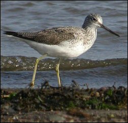
Photographer - Tom Shevlin
Twitter FeedWeb site featuring Tom Shevlin`s photographs of birds and other Irish wildlife