
Free and Sovereign State of Durango
Durango is one of the 31 states which make up the 32 Federal Entities of Mexico, situated in the northwest portion of the country. With a population of under two million people, the 8th lowest of Mexico’s states, it has Mexico’s second-lowest population density, after Baja California Sur. The capital and largest city is Victoria de Durango with a population of about three quarters of a million inhabitants. Durango is landlocked and bordered to the north by Chihuahua, to the northeast by Coahuila, to the southeast by Zacatecas, to the southwest by Nayarit, and to the west by Sinaloa.
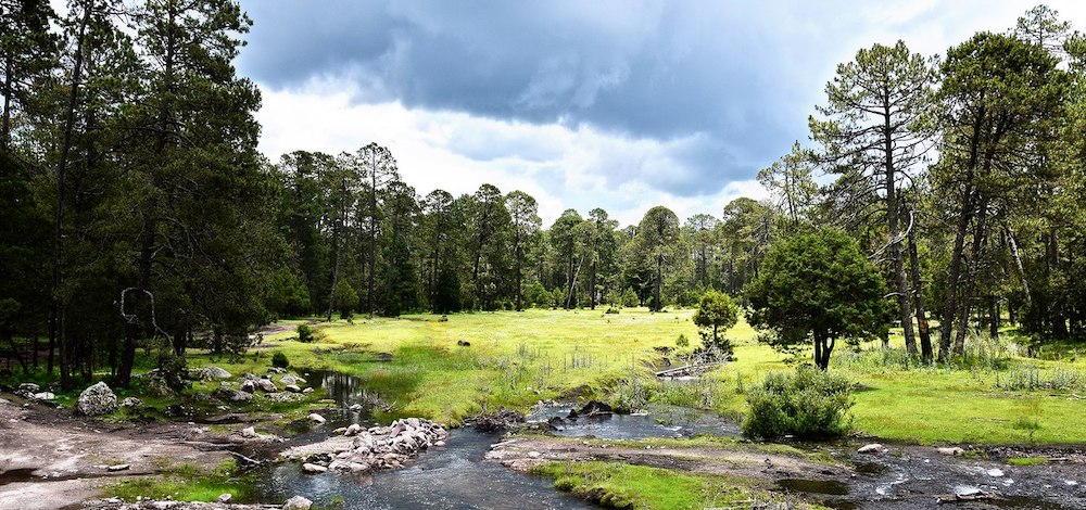
Most of the state is mountainous and was heavily forested, the Sierra Madre Occidental occupies the western and central part of the state and blocks the moisture of the Pacific Ocean. This mountain range contains a good supply of minerals, including the silver that encouraged Spanish occupation of the territory after it was discovered. These mines extend north into Chihuahua and south into the state of Zacatecas. The denuded forest is being replanted with native species. Many rivers begin in Durango, but lead into other Mexican states. Some of these rivers empty into the Pacific, or into the lake area of La Comarca, while one, the Florida, flows into the Gulf of Mexico.
Durango is famous for its scorpions. Mexicans generally refer to the people of Durango as Alacrán de Durango (A scorpion from Durango). The demonym for the natives of Durango is Duranguenses. The major occupations in Durango are farming, lumbering and ranching.
Mexiquillo, Durango – ©México en Fotos, A.C., CC BY-SA 2.0 Wikimedia Commons
Birding Durango
Ecologically, the state is divided into four regions: La Quebrada, the Sierra, the Valleys and the Semi-desert. The desert is mostly in the northeast of the state where the terrain is flat and the climate dry. Vast desert basins in the Laguna District are irrigated by the Nazas River. Major crops grown in the area include cotton, wheat, corn, alfalfa, marijuana, beans, sorghum, and other vegetables. There is a shallow wetland area called the Guatimapé, or Santiguillo. It provides vital habitat for flocks of migrating birds in winter, especially cranes, geese and ducks.
The Sierra region is in the west of the state. The terrain is rugged with freezing temperatures in the winter and snow in the higher elevations. There is also a rainy season in the summer. The vegetation in the Sierra region is mostly pine–oak forest, consisting of pines, oak, cedar, and strawberry trees as well as grasslands.
Las Quebradas is found in the far west of the state. The region is subdivided by the rugged, western flank of the Sierra Madre. The terrain features deep ravines, canyons and fast-flowing rivers. The Humaya, Tamazula, Los Remedios, Piaxtla, Presidio, and Baluarte rivers flow west to the Pacific through the state of Sinaloa. Further south, the Acaponeta, San Pedro Mezquital, and Huaynamota rivers flow southwest through the state of Nayarit. The region, especially its ravines and canyons, is hot and humid. It receives the most rainfall in the state. This area is home to the La Michilía Biosphere Reserve, which is a pioneer for the reintroduction of the critically endangered Mexican grey wolf. The Tecuan National Forest is also in the Quebradas.
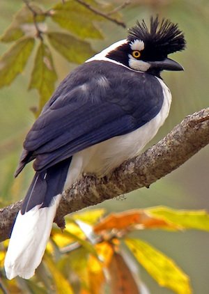
With over 500 species recorded Durango offers great birding for all tastes including Mexican endemics.
-
Zona del silencio
WebsiteSatellite ViewZona del silencio is located in Durango and Coahuila in the north of Mexico and is a dessert ecosystem.
-
Wikipedia
GNU Free Documentation License
https://en.wikipedia.org/wiki/Durango
-
Number of bird species: 508
(As at June 2024)
-
Avibase
PDF ChecklistThis checklist includes all bird species found in Durango , based on the best information available at this time. It is based on a wide variety of sources that I collated over many years. I am pleased to offer these checklists as a service to birdwatchers. If you find any error, please do not hesitate to report them.
-
BR La Michilía Biosphere Reserve
InformationSatellite ViewLa Michilía Biosphere Reserve is a protected area in northwestern Mexico. It is located in the Sierra Madre Occidental range in the south of the state of Durango. -
BR Mapimí
InformationSatellite ViewThey are recognized around 270 species of vertebrates, among them five amphibians, 36 reptiles, 28 mammals and approximately 200 birds (Aguirre and Maury, 1989). This protected natural area preserves typical fauna of the semi-arid regions of the Mexican Plateau, including species of birds threatened like aguililla red tail (Buteo jamaicensis, aguililla rojinegra (Parabuteo unicinctus); the pale hawk (Falco mexicanus); lechuza of madriguera (cunicularia Athene) and the real eagle (Aquila chrysaetos). -
SP Cañon de Fernández State Park
InformationSatellite ViewCañon de Fernandez State Park is a natural protected area in the northern Mexican state of Durango. It covers 17,000 hectares straddling the Nazas River in Lerdo Municipality, right in the middle of the Chihuahuan Desert.
-
BirdQuest
Tour OperatorBirdquest’s Western Mexico birding tours are the most comprehensive birding tours available to this bird-rich region of North America. Our ultimate Western Mexico birding tours -
Naturalist Journeys
Tour OperatorRelax this winter on a private ranch in western Mexico, with West Mexican Chachalacas as your alarm clock and Black-throated Magpie-Jays over coffee.
-
2023 [04 April] - Pete Morris
PDF ReportWith just the odd tweak here and there, our well-established Western Mexico tour has, over the years, become a very efficient clean-up (or nearly!) of the many regional specialities that this fantastic part of Mexico has to offer