
State of Ceará
Birding Ceará
Ceará is one of the 27 states of Brazil, located in the northeastern part of the country, on the Atlantic coast. It is the eighth-largest Brazilian State by population and the 17th by area. It is bounded on the north by the Atlantic Ocean, on the east by the states of Rio Grande do Norte and Paraíba, on the south by Pernambuco state, and on the west by Piauí.The climate of Ceará is hot almost all year. The temperature in the state varies from 22 to 36 °C (72 to 97 °F). The year is divided into a rainy and dry season, the rains beginning in January to March and lasting until June. The dry season, July to December, is sometimes broken by slight showers in September and October, but these are of slight importance. The state is also one of the main tourist destinations in Brazil. The state capital is the city of Fortaleza, the country’s fourth most populous city. Literally, the name Ceará means ‘sings the jandaia’. According to José de Alencar, one of the most important writers of Brazil and an authority in Tupi Guaraní, Ceará means turquoise or green waters. There are also theories that the state name would derive from Siriará, a reference to the crabs from the seashore.The state is best known for its extensive coastline, with 600 kilometers of sand. There are also mountains and valleys producing tropical fruits. To the south, on the border of Paraíba, Pernambuco and Piauí, is the National Forest of Araripe. Ceará has a varied environment, with mangroves, caatinga, jungle, scrubland and tropical forest. The higher ranges intercept considerable moisture from the prevailing trade winds, and their flanks and valleys are covered with a tropical forest which is typical of the region, gathering species from tropical forests, caatinga and cerrado. The less elevated areas of the plateaus are either thinly wooded or open campo. Most of the region at the lower altitudes is characterised by scrubby forests called caatingas, which is an endemic Brazilian vegetation. The sandy, coastal plain, with a width of 19 to 29 km, is nearly bare of vegetation, although the coast has many enclaves of restingas (coastal forests) and mangroves.The rivers of the state are small and, with one or two exceptions, become completely dry in the dry season. The largest is the Jaguaribe, which flows entirely across the state in a northeast direction.Below are some of its top attractions and websites to the reserves and many places to stay where birding is an option. We welcome a proper introduction to this page from someone who knows the area well.
-
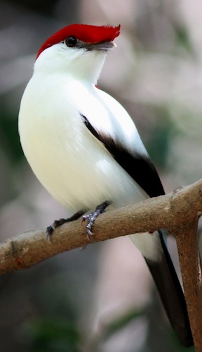
Araripe
Satellite ViewThis is the mecca for the Araripe Manakin Antilophia bokermanni. In the town of Barbalha ask for the Nascente do Farias, a swimming and picnic spot about 10km west of the town. The manakins are in the trees along the two streams that flow from the spring at the foot of the hill. -
Baturité
Satellite ViewThese 800m high hills south of Fortaleza have some interesting birds. In the private forest behind the Hotel Remanso can be found Gould's Toucanet Selenidera gouldii, Buff-breasted Tody-tyrant Hemitriccus mirandae and the distinctive race of Rufous Gnateater Conopophaga lineata cearae. -
Parque Nacional de Ubajara
Satellite ViewThe national park with a cable car to a waterfall at the bottom is spectacular. In the park and in the forest remnant behind the IBAMA headquarters (between Ubajara and Tianguá) we saw Hooded Gnateater Conopophaga roberti and Buff-breasted Tody-tyrant Hemitriccus mirandae. There is good caatinga west of Tianguá, near the Piauí border, where we found the normal specialites of this habitat, including Broad-tipped Hermit Phaethornis gounellei and Great Xenops Megaxenops parnaguae.
-
Number of bird species: 502
(As at May 2019)
-
Universidade Federal do Cear
Website
-
NP Ubajara National Park
InformationSatellite ViewIt is the smallest of the 35 national parks of Brazil and is known for the Ubajara grotto. The park adjoins the 1,592,550 hectares (3,935,300 acres) Serra da Ibiapaba Environmental Protection Area to the west. Protected species in the park include the oncilla (Leopardus tigrinus), cougar (Puma concolor), Maranhão red-handed howler (Alouatta ululata), and the variable antshrike. -
NR Reserva Mãe-da-Lua
Observatory WebsiteSatellite ViewRPPN is located in the municipality of Itapajé in Ceará, 120 km from Fortaleza. It includes a large part of the east and north sides of the Serra das Vertentes (approximately 400 hectares of the reserve) and plain in the south of the mountain (360 hectares).
-
Ciro Albano - NE Brazil Birding Guide
Tour OperatorI’m a ornithologist, bird photographer and birdwatching guide from NE Brazil. I hope you like the photos and decide to come birding in NE Brazil – the land of the contrasts.