
Republic of Benin
Benin is a country in Western Africa. It borders Togo to the west, Nigeria to the east and Burkina Faso and Niger to the north; its short coastline to the south leads to the Bight of Benin. Its size is just over 110,000 km² so is roughly the size of Pennsylvania, Benin extends from the Niger River in the north to the Atlantic Ocean in the south, a distance of 700 kilometres (c.500 miles). There is a population of a little over 14 million people, mostly living in the south. Its capital is the Yoruba founded city of Porto Novo, but the seat of government is the Fon City of Cotonou. (Benin was known as Dahomey until 1975). Although the coastline measures 121 kilometres (about 80 miles) the country measures about 325 kilometres (about 215 miles) at its widest point. It is one of the smaller countries in West Africa: eight times smaller than Nigeria, its neighbour to the east, but, twice the size of Togo, its neighbour to the west.
A relief map of Benin shows that it has little variation in elevation (average elevation 200 meters). The country can be divided into four areas from the south to the north. The low-lying, sandy, coastal plain (highest elevation 10 meters) is, at most, 10 kilometres wide. It is marshy and dotted with lakes and lagoons communicating with the ocean. The plateaus of southern Benin (altitude between 20 meters and 200 meters) are split by valleys running north to south along the Couffo, Zou, and Oueme Rivers. An area of flat lands dotted with rocky hills whose altitude seldom reaches 400 meters extends around Nikki and Save. Finally, a range of mountains extends along the northwest border and into Togo; this is the Atacora, with the highest point, Mont Sokbaro, at 658 meters. Two types of landscape predominate in the south. Benin has fields of lying fallow, mangroves, and remnants of large sacred forests. In the rest of the country, the savanna is covered with thorny scrubs and dotted with huge baobab trees. Some forests line the banks of rivers. In the north and the northwest of Benin the Reserve du W du Niger and Pendjari National Park attract tourists eager to see elephants, lions, antelopes, hippos, and monkeys.
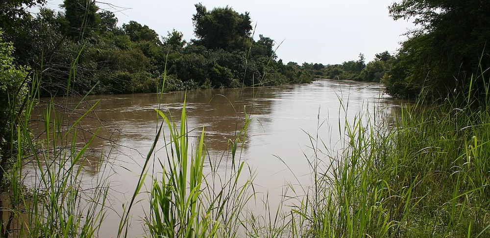
Mekrou River – ©Marco Schmidt, CC BY-SA 3.0 < >, via Wikimedia Commons
Benin’s climate is hot and humid. Annual rainfall in the coastal area averages 14 inches, not high for coastal West Africa. Benin has two rainy and two dry seasons. The principal rainy season is from April to late July, with a shorter less intense rainy period from late September to November. The main dry season is from December to April, with a short cooler dry season from late July to early September. Temperatures and humidity are high along the tropical coast. In Cotonou, the average maximum temperature is 31 °C; the minimum is 24 °C. Variations in temperature increase when moving north through a savanna and plateau toward the Sahel. A dry wind from the Sahara called the Harmattan blows from December to March. Grass dries up, the vegetation turns reddish brown, and a veil of fine dust hangs over the country, causing the skies to be overcast. It also is the season when farmers burn brush in the fields.
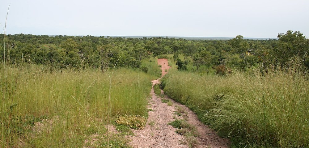
Reserve du W du Niger – ©Marco Schmidt, CC BY-SA 3.0 via Wikimedia Commons
It is a small, tropical country. It is one of the least developed, with an economy heavily dependent on agriculture, and is an exporter of palm oil and cotton. Four terrestrial ecoregions lie within Benin’s borders: Eastern Guinean forests, Nigerian lowland forests, Guinean forest-savanna mosaic, and West Sudanian savanna.
Birding Benin
Benin has varied resources of wildlife comprising flora and fauna, which are primarily protected in its two contiguous protected areas of the Pendjari National Park and W National Park., which is a transboundary park across parts of Niger, Benin and Burkina Faso, as a part of the Niger River, encompasses an area of 563,280 hectares (1,391,900 acres) in Benin. The ‘W’ refers to the W-shaped bends in the Niger River that borders the park and which is fed by the Tapoa River in the north, and the Mékrou River in the south. It is known for many species of avifauna and the latter park is rich in mammals and predators. In addition, many other forest reserves are noted in the country but are not easily accessible, well protected or adequately surveyed for its wildlife resources. The Pendjari National Park covers 275,500 hectares (681,000 acres) entirely in the far north-west of Benin. The Pendjari River Valley was recognized as a wetland of international importance and designated as a Ramsar site.
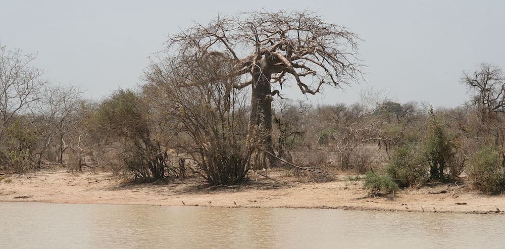
Pendjari National Park – ©Dominik Schwarz, CC BY-SA 3.0 via Wikimedia Commons
The protected area of Benin which is defined as a National Protected Area System is in northern Benin, mostly with a woody savanna ecosystem covering 10% of the country. Forests of particular note are the riparian forests which form a dominant ecosystem, accounting for one-third of the estimated flora of 3,000 species in Benin. These forests are found along river banks consisting of semi-deciduous, dry, and open forest and woodland savanna. However, these systems have been subject to severe misuse by way of deforestation, which necessitated the enforcement of a law, which imposes restrictions on cutting of these forests.
Predators include: Lions Panthera leo, the largest predator of Africa (found in both parks); Leopards Panthera pardus found even outside the two parks; Cheetahs Acinonyx jubatus is in the national parks but is a rare sight; several Felis silvestris, a smaller cat; the Caracal Caracal caracal, the African Wild Cat Felis sylvestris; the African Hunting Dog Lycaon pictus said to be in W. Park (may be extinct); Side-striped Jackal Canis adustus; the Black-backed Jackal Canis mesomelas; the Spotted Hyena Crocuta crocuta found in both parks, Elephants, Rhinos, Buffalos and many other animals including several mongoose species, antelopes, small cats, Honey Badger and Otters. Primates reported include Olive Baboon Papio anubis of large size with inverted U-shaped tail; the Green Monkey Cercopithecus sabaeus, the most common monkey species; the Common Patas Monkey Erythrocebus patas with an orange tinged coat occur in northern Benin. Reptiles include turtles, crocodiles and chameleons.
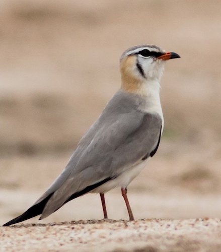
Birds are a special feature in all types of habitats ranging from rainforest to deserts in Benin, which have two main climatic zones, namely the thick tropical vegetation in the south and the dry savannas and light woodlands in the north. The birding sites for coastal waders are the coastal lagoons of Les Bouches du Roi and the backwaters of Ouidha beach. Water and forest birds are found in Lake Nokoué and Lake Ahémé. Feathered birds are found in granite rock hills near Dassa-Zoume. The national parks are full of savanna specific birds including no less than twelve species of weavers. Raptor species (mostly carion-eating birds) are found in both parks. A common sight is the African Fish Eagle Haliaeetus vocifer.
This page is sponsored by Ashanti African Tours
-
Important Bird Aeas include:
Lake Ah
-
Wikipedia
GNU Free Documentation License
http://en.wikipedia.org/wiki/Benin
-
Number of bird species: 603
(As at August 2024)
-
Avibase
PDF ChecklistThis checklist includes all bird species found in Benin , based on the best information available at this time. It is based on a wide variety of sources that I collated over many years. I am pleased to offer these checklists as a service to birdwatchers. If you find any error, please do not hesitate to report them. -
Wikipedia
Annotated ListThis is a list of the bird species recorded in Benin. The avifauna of Benin include a total of 600 species. -
eBird
PDF ChecklistThis checklist is generated with data from eBird (ebird.org), a global database of bird sightings from birders like you. If you enjoy this checklist, please consider contributing your sightings to eBird. It is 100% free to take part, and your observations will help support birders, researchers, and conservationists worldwide.

-
Birds of Western Africa
| By Nik Borrow & Ron Demey | Christopher Helm | 2014 | Edition 2 | Paperback | 592 pages, 266 plates with colour illustrations; colour distribution maps | ISBN: 9781472905680 Buy this book from NHBS.com -
Birds of Western and Central Africa
| By Ber van Perlo | Princeton University Press | 2003 | Paperback | 384 pages, 109 plates with colour illustrations; colour & b/w illustrations, 1500+ b/w distribution maps, colour maps | Out of Print | ISBN: 0691007144 Buy this book from NHBS.com -
The Birds of Benin and Togo
| An Atlas and Handbook | By Françoise Dowsett-Lemaire & Robert J Dowsett | Tauraco Press | 2019 | Paperback | 692 pages, 22 plates with colour photos; 570 colour distribution maps | ISBN: 9782872250080 Buy this book from NHBS.com
-
African Bird Club
WebsiteIn comparison with some of its neighbours, the avifauna of Benin has been poorly studied. Until 1993 only 425 species had been recorded. This was in comparison with 625 for Togo, its neighbour in the Dahomey Gap -
West African Ornithological Society
WebsiteThe West African Ornithological Society grew out of the Nigerian Ornithologists
-
*Protected areas of Benin
InformationSatellite View2 Biosphere Reserves, two national parks and four Ramsar sites -
Important Bird Areas
WebsiteSatellite ViewClickable list with site descriptions -
NP Pendjari Biosphere Reserve
WebpageSatellite ViewPendjari is a conservation stronghold in West Africa, which forms part of a critically important triad of national parks and reserves where 90% of the population of West African lions remain. -
NP W
InformationSatellite ViewThe W National Park is a major national park in West Africa around a meander in the River Niger shaped like the letter W. The park includes areas of the three countries Niger, Benin and Burkina Faso, and is governed by the three governments. The W National Park is also known for its bird populations, especially transitory migrating species, with over 350 species identified in the park. The park has been identified by BirdLife International as an Important Bird Area...
-
eBird
SightingseBirding This Month
-
Adventurew Birding
Tour OperatorUnique 19 Days Ghana, Togo, Benin Birding Tour, is carefully packaged to cover interesting birding sites for a variety of Upper Guinea Endemics Species of Birds and Mammals. -
Ashanti
Tour Operator...ntelope species are in abundance here and the birdlife is exceptional with key specie Pel’s Fishing Owl, Standard-winged nightjar and Rufous-rumped Lark regularly seen. Stunning landscapes await and we can customize tailor-made itineraries to incorporate other areas of interest... -
Exploring Tourism Benin
Tour OperatorDiscovery Tour Of Lake Ganvié And The Island Of Paradi
-
2016 [09 September] - Sash Tusa
PDF ReportThis was primarily a business trip, so birding was generally snatched opportunities in the region of the capital, Cotonou. A number of short (2-3 hour) trips really highlighted the excellent birding potential of this part of the country, plus the real potential for cetacean-watching from the shore. -
2018 [10 October] - Jean Hugé
PDF ReportIn Natitingou, in the north of the country, where our worshop was held, I got good views of Yellow-billed Shrike in the shrubs near Place Kaba (the main roundabout when you enter town from the South). Village Indigobird, Northern Grey-headed Sparrow, Scarlet-chested Sunbird and Blue-naped Mousebird were common. At night, we heard a calling African Scops Owl from the rooftop terrace of ‘Hotel Kaba Le Héros’. Natitingou did not strike me as a particularly nice place (except for its central location in Benin’s beautiful northern region), but the restaurant ‘La brèche de Nati’ is worth mentioning. -
2024 [02 February] - Benoit Willocx
PDF ReportDuring a cooperation trip to Benin, I took advantage of the little free time I had to get out my binoculars and camera and observe the birds around me. The trip was limited to the south of Benin.
-
Malimbus
WebpagePapers, Short Notes, Research Grant Reports and Reviews about birds of Benin that have appeared in Malimbus and the Bulletin of the Nigerian Ornithologists' Society (Bull NOS) Remember the reference and click on the link in the Reference column for further information: ROL abstract (papers and notes), authors' summary (papers) or full text (published more than five years ago).