
Free and Sovereign State of Baja California
Baja California is the northernmost and westernmost state of the 32 states of Mexico. It has an area of c. 70,000 km2 (c. 27,000 square miles), or 3.57% of the land mass of Mexico and comprises the northern half of the Baja California peninsula, north of the 28th parallel, plus oceanic Guadalupe Island. The state is bordered on the west by the Pacific Ocean, on the east by Sonora, the US State of Arizona, and the Gulf of California (also known as the Sea of Cortez), and on the south by Baja California Sur. Its northern limit is the US state of California. It has a population of around four million and its capital is Mexicali, home to over a million people.
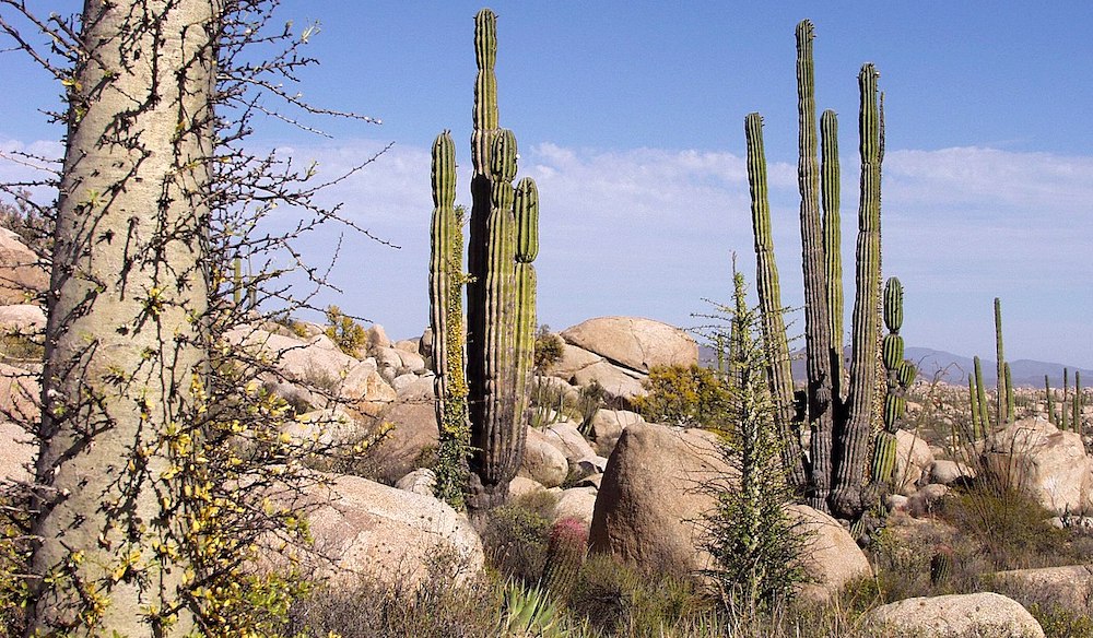
Baja California is the twelfth state by area in Mexico. Its geography ranks from beaches to forests and deserts. The backbone of the state is the Sierra de Baja California; where the Picacho Del Diablo, the highest point of the peninsula, is located. This mountain range effectively divides the weather patterns in the state. In the northwest, the weather is semi-dry, Mediterranean. In the narrow centre, the weather changes to be more humid due to altitude. It is in this area where a few valleys can be found, such as the Valle de Guadalupe, the major wine producer area in Mexico. To the east of the mountain range, the Sonoran Desert dominates the landscape. In the south, the weather becomes drier and gives place to the Vizcaino Desert. The state is also home to numerous islands off both of its shores. In fact, the westernmost point in Mexico is Baja California’s Guadalupe Island. The Coronado, Todos Santos and Cedros Islands are also on the Pacific Shore. On the Gulf of California, the biggest island is the Angel De La Guarda, separated from the peninsula by the deep and narrow Canal de Ballenas.
Temperate winds from the Pacific Ocean and the cold California Current make the climate along the northwestern coast pleasant year-round. As a result of the state’s location on the California Current, rains from the north barely reach the peninsula, thus leaving southern areas drier. South of the El Rosario River, the state changes from a Mediterranean landscape to a desert one. This desert exhibits diverse succulent species that flourish in part due to the coastal fog. To the east, the Sonoran Desert enters the state from both California and Sonora. Some of the highest temperatures in Mexico are recorded in or nearby the Mexicali Valley.
Baja California Desert – ©Tomas Castelazo, CC BY-SA 2.5 via Wikimedia Commons
Baja California has two sea shores. It borders the Pacific Ocean to the west and the Gulf of California to the east. Even though the state is not large in area, its geography is very diverse. The Sierra de Baja California (also known as the Peninsular Ranges) runs in the middle of the state with different denominations. The two most important are the Sierra de Juarez and the Sierra de San Pedro Martir. These ranges are home to forests similar to those in Southern California. The Picacho del Diablo is the highest peak in the whole peninsula, offering spectacular views of the Gulf of California. Lying in between these mountain ranges, there are some valleys that are suitable for agriculture such as the Valle de Guadalupe and the Valle de Ojos Negros. The mild weather makes this area excellent for the production of citrus fruits and grapes. This area is also rich in minerals. The mountain range gets closer to the Gulf of California towards the south of the state and the western slope becomes wider, forming the Llanos del Berrendo in the border with Baja California Sur. The cool winds from the Pacific Ocean and the cold California Current make the weather along the northwestern coast pleasant year-round. But due to the California current, rains from the north barely reach the peninsula and this makes the weather drier towards the south. The area becomes a desert south of El Rosario River. This desert, however, is rich in succulents such as the Cardon, Boojum tree, Ocotillo and others. These plants can flourish in part due to the coastal fog. Driving along MX-1 provides a good view of this area.

Tijuana River – ©Herb Neufeld, CC BY 2.0 via Wikimedia Commons
The main source of water in the state are the Colorado River, which empties in the Gulf of California, and the Tijuana River, serving the cities of Mexicali and Tijuana. The rest of the state depends mostly on wells and a few dams.
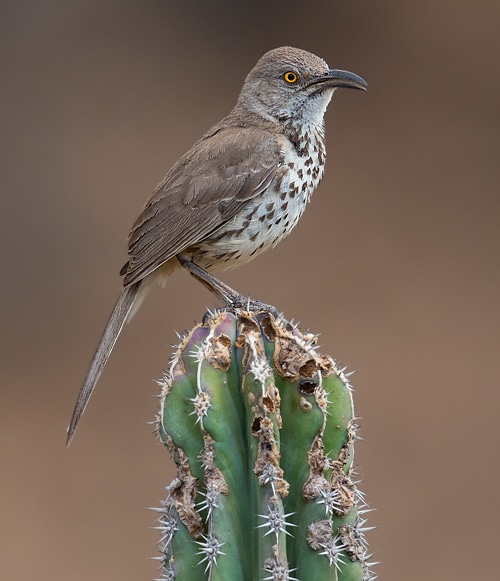
Birding Baja California
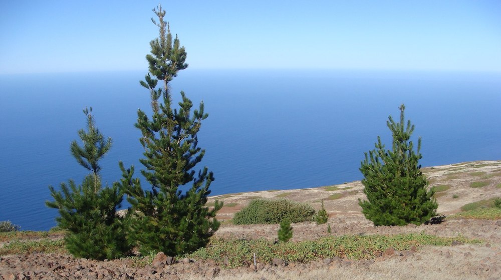
The flora of Baja California is strongly related to those of Southern coastal California. Common trees are the Jeffrey Pine, Sugar Pine and Pinon Pine. Understory species include Manzanita. Fauna include a variety of reptiles including the Western fence lizard, which is at the southern extent of its range.
In the main wildlife refuges on the peninsula of Baja California, Constitution 1857 National Park and Sierra de San Pedro Mártir National Park, several coniferous species can be found. The most abundant is Jeffrey Pine. The lower elevations of the Sierra de Juárez are characterized by chaparral and desert shrub. Guadalupe Island and its surrounding waters, 250 kilometres (160 miles) off the Pacific coast, has been designated the Guadalupe Island Biosphere Reserve to preserve endangered marine and terrestrial species of animals and plants, where there was a problem with feral goats and cats. The goats have been eliminated entirely, and the reaming cats should be removed by 2025.
Guadalupe Island Biosphere Reserve – ©Ignacio March Mifsut, CC BY-SA 4.0 via Wikimedia Commons
The fauna in the parks include a large number of mammals, primarily mule deer, bighorn sheep, cougars, bobcats, ringtail cats, coyotes, rabbits, squirrels and more than 30 species of bats. The park is also home to many avian species like Bald Eagles, Golden Eagles, a number of Falcons and Woodpeckers, Black Vultures, several crow species, and several species of hummingbirds, nuthatches, sparrows and duck. The islands hold many pelagic species.
-
Wikipedia
GNU Free Documentation License
http://en.wikipedia.org/wiki/Baja_California
-
Number of bird species: 504
(As at August 2024)
Number of endemics: 3
Guadalupe Storm-Petrel Hydrobates macrodactylus
Guadalupe Junco Junco insularis
Ainley's Storm-Petrel Hydrobates cheimomnestes- However, there are a further three species confined to the peninsular. They are:
Cape Pygmy Owl Glaucidium hoskinsii
Gray Thrasher Toxostoma cinereum
Xantus’s Hummingbird Basilinna xantusiiOther potential future splits in Baja may include Vizcaino Thrasher Toxostoma (lecontei) arenicola
San Lucas Robin Turdus migratorius confines
-
Avibase
PDF ChecklistThis checklist includes all bird species found in Baja California , based on the best information available at this time. It is based on a wide variety of sources that I collated over many years. I am pleased to offer these checklists as a service to birdwatchers. If you find any error, please do not hesitate to report them. -
Mexico Birding
PDF ChecklistField Checklist of The Birds of Baja California -
eBird
PDF ChecklistThis checklist is generated with data from eBird (ebird.org), a global database of bird sightings from birders like you. If you enjoy this checklist, please consider contributing your sightings to eBird. It is 100% free to take part, and your observations will help support birders, researchers, and conservationists worldwide.

-
Birds of Mexico and Central America
| By Ber Van perlo | Princeton University Press | 2006 | paperback | 336 pages, 98 plates with colour illustrations; b/w illustrations, b/w distribution maps, colour maps | ISBN: 9780691120706 Buy this book from NHBS.com -
Mexico Field Guides: Baja California
| (Sea of Cortez - Pacific Coast: Sea and Shore Birds) By Robert Dean | Rainforest Publications | 2002 | Unbound | 2 pages, colour illustrations | ISBN: 9781888538366 Buy this book from NHBS.com
-
Birding Baja
Facebook PageBirds in Loreto and surroundings.
-
*Protected areas of Baja California
InformationSatellite ViewBiosphere reserves, national parks etc. -
BR Guadalupe Island Biosphere Reserve
InformationSatellite ViewThe Guadalupe Island Biosphere Reserve, (Reserva de la Biosfera Isla Guadalupe in Spanish), is in the Pacific Ocean and part of Baja California state of Mexico. The Reserve consists of Guadalupe Island and several small islands nearby plus a large expanse of surrounding ocean. An important nesting place for 22 species of seabird -
BR Montague Island
InformationSatellite ViewThe birds nesting on Montague Island have reacted strongly to El Niño, with brown boobies being replaced by blue-footed boobies, and an increase in nesting of least, elegant, and royal terns, as well as black skimmers. -
NP 1857 Constitution
Facebook PageSatellite ViewThe 185 Constitution National Park is in the Sierra de Juárez, mountain range, approximately 45 miles east of Ensenada. Within its 5,009 hectares (12,400 acres); is one of interior Baja California's few semi-permanent bodies of water, Laguna Hanson…
-
Baja Adventures
Local Tour OperatorOur expeditions in Baja California Sur are operated by Baja Adventures, a sister company specializing in regenerative tourism. We focus on seasonal migrations of various species across diverse ecosystems, enhancing tourism from ocean to mountains. -
BirdQuest
Tour OperatorWESTERN MEXICO – The ultimate itinerary in the region: Sierra Madre Occidental, San Blas, Colima, Jalisco & Baja California -
Birding Direct
Local Tour OperatorBaja Birding Pelagic -
Birding Los Cabos
Local Tour OperatorLet the local Birding Los Cabos experts' guides help you accomplish your life-list, Will be a great honor to show you around and the birds through Tours, Journeys -
Boletas
Tour OperatorEndemics : Cape Pygmy Owl, San Lucas Robin, Xantus´s Hummingbird, Belding's Yellowthroat, Baird's Junco, Yellow-footed Gull, Grey Thrasher, Gilded Flicker, Gila Woodpecker, Blue Footed Booby, Heerman´s Gull, Willson´s Plover, Harris's Hawk. -
FieldGuides
Tour OperatorCENTRAL MEXICO & BAJABirds, Butterflies & Whales Specialty birds, wintering Monarchs, and up-close whale encounters on this exciting tour! -
Pitta Nature Tours
Tour OperatorThe 770-mile long Baja Peninsula is a unique extension of the familiar Sonoran Desert of the American Southwest -
Tropical Birding Tours
Tour OperatorThis is a relaxed winter tour sprinkled with endemic and specialty birds, beautiful desertscapes, and also includes whale-watching boat trips, plus an option to snorkel with Whale Sharks too... -
WINGS
Tour OperatorConnected to North America by a 770-mile peninsula, the Cape Region of Baja California is in some ways a familiar place, with many of the area’s plants and animals also found in California or the Sonoran desert of Arizona and west Mexico. -
WildWings
Tour OperatorBaja California and the Sea of Cortez
-
2018 [01 January] - Rob Gordijn & Helen Rijkes
PDF ReportAfter visiting Yucatan in 2008 we decided to come back to Mexico but this time bird the Western part of the country.We hired a car in Mexico City and birded the main West Mexico sites (around the cities of Mazatlan, San Blas, PuertoVallarta and Colima) and as an addition we extended the trip to Baja California and added some places around MexicoCity -
2019 [02 February] - Greg Smith
PDF ReportAnnotated list -
2022 [03 March] - Greg Smith - Sea of Cortez
PDF ReportAnnotated list
-
Rancho Cacachilas
Accommodation and BirdingCalling all bird enthusiasts! Embark on an unforgettable adventure with our exclusive Bird Watching Tour at our Rancho Cacachilas.
-
Aves de Baja California
WebsiteA site to learn and share information about the wild birds of Baja California peninsula...