
Manipur
Manipur is a state in northeastern India with Imphal as its capital. It borders the Indian states of Assam to the west, Mizoram to the south, and Nagaland to the north and shares the international border with Myanmar, specifically the Sagaing Region to the east and Chin State to the southeast. Covering an area of 22,330 km2 (8,621 square miles), with a population of around 3.2 million people. The state consists mostly of hilly terrain. It has primarily an agrarian economy, with significant hydroelectric power generation potential. It is connected to other areas by daily flights through Imphal Airport. Manipur is home to many sports and the origin of Manipuri dance and is credited with introducing polo to Europeans. The capital lies in an oval-shaped valley of approximately 2,000 km2, surrounded by blue mountains, at an elevation of c.2,500 feet. The slope of the valley is from north to south. The mountain ranges create a moderate climate, preventing the cold winds from the north from reaching the valley and barring cyclonic storms.
There are four major river basins: the Barak River Basin (Barak Valley) to the west, the Manipur River Basin in central Manipur, the Yu River Basin in the east, and a portion of the Lanye River Basin in the north. The Barak River, the largest of Manipur, originates in the Manipur Hills and is joined by tributaries, such as the Irang, Maku, and Tuivai. After its junction with the Tuivai, the Barak River turns north, forms the border with Assam State, and then enters the Cachar Assam just above Lakhipur. The Manipur River basin has eight major rivers: the Manipur, Imphal, Iril, Nambul, Sekmai, Chakpi, Thoubal and Khuga. All these rivers originate from the surrounding hills. Almost all the rivers in the valley area are in the mature stage and therefore deposit their sediment load into Loktak Lake. The rivers draining the Manipur Hills are comparatively young, due to the hilly terrain through which they flow. These rivers are corrosive and become turbulent in the rainy season. Important rivers draining the western area include the Maku, Barak, Jiri, Irang, and Leimatak. Rivers draining the eastern part of the state, the Yu River Basin, include the Chamu, Khunou and other short streams.
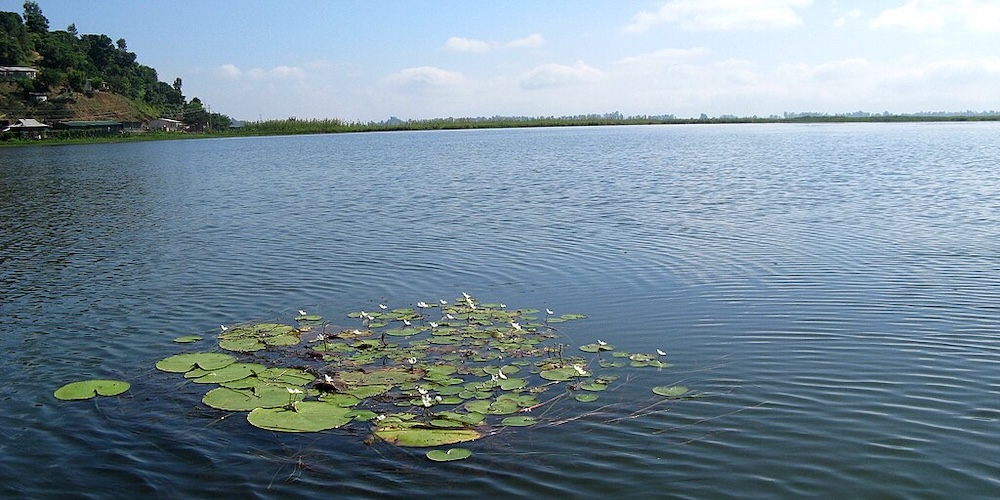
Loktak Lake – ©ch_15march CC BY 2.0 via Wikimedia Commons
Manipur may be characterised as two distinct physical regions: an outlying area of rugged hills and narrow valleys, and the inner area of flat plain, with all associated landforms. These two areas are distinct in physical features and are conspicuous in flora and fauna. The valley region has hills and mounds rising above the flat surface. Loktak Lake is an important feature of the central plain. The total area occupied by all the lakes is about 600 km2. The altitude ranges from 40 m at Jiribam to 2,994 m at Mount Tempü peak along the border with Nagaland.
Manipur’s climate and soil conditions make it ideally suited for horticultural crops. Growing there are rare and exotic medicinal and aromatic plants. Some cash crops suited for Manipur include Lychee, Cashew, Walnut, Orange, Lemon, Pineapple, Papaya, Passion Fruit, Peach, Pear and Plum. The state is covered with over 3,000 km2 (1,200 square miles) of bamboo forests, making it one of India’s largest areas of bamboo. Agriculture in Manipur includes a number of smallholding farms, many of whom are owned by women. Rubber, tea, coffee, orange, and cardamom are grown in hill areas. Rice is a staple food for Manipuris.
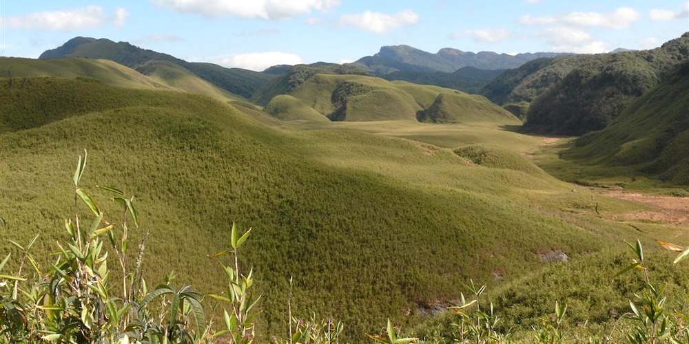
Dzukou Valley – ©Mongyamba CC BY-SA 3.0 via Wikimedia Commons
Natural vegetation occupies an area of about 17,418 km2 (6,725 square miles), over 75% of the total area of the state, and consists of short and tall grasses, reeds and bamboos, and trees. About a third of Manipur’s forests are protected.
There are six major types of forests in Manipur, which include Tropical Wet Evergreen Forest, Tropical Moist Deciduous Forests, Sub-Tropical Pine Forest, Tropical Dry Deciduous Forest, Montane Wet Temperate Forest and Sub-alpine Forest. The are forests of teak, pine, oak, uningthou, leihao, bamboo, and cane.
Manipur’s climate is largely influenced by the topography of the region. Lying 790 metres above sea level, Manipur is wedged among hills on all sides. This northeastern corner of India enjoys a generally amiable climate, though the winters can be chilly. The maximum temperature in the summer months is 32 °C. The coldest month is January, and the warmest July. The average annual rainfall is about 58 inches, mostly between April and mid-October. Precipitation ranges from light drizzle to heavy downpour. The capital city Imphal receives an annual average of 37 inches. Rainfall in this region is caused by The South Westerly Monsoon picking up moisture from the Bay of Bengal and heading towards the Eastern Himalaya ranges. This normal rainfall pattern of Manipur enriches the soil and much of the agrarian activities are dependent on it as well.
Birding Manipur
Manipur has two national parks and a number of wildlife sanctuaries. Keibul Lamjao National Park, 48 kilometres away from Imphal, is home to rare and endangered species including brow antlered deer. This ecosystem suits 17 rare species of mammals. It is the only floating national park in the world. Six kilometres to the west of Imphal, at the foot of the pine growing hillocks at Iroisemba on the Imphal-Kangchup Road are the Zoological Gardens. Some brow antlered deer (Sangai) are housed there.
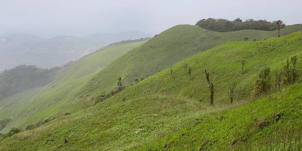
Sirohi National Park – ©Devadarshan Sharma CC BY-SA 4.0 via Wikimedia Commons
There are at least nine recognised IBAs including the Anko Hills in Ukhrul District; Bunning Wildlife Sanctuary & Zeilad Lake Sanctuary in Tamenglong District; Dzuku Valley in Senapati District; Kailum Wildlife Sanctuary; Loktak Lake & Keibul Lamjao National Park and Yangoupokpi Lokchao in the Chandel District. Loktak Lake is the largest fresh water Lake of North-Eastern India and a Ramsar site. Loktak Lake ecosystem is threatened by excessive loading of silt and nutrients from various anthropogenic sources. Deforestation, shifting cultivation, uncontrolled use of fertilisers in agricultural lands, and discharge of domestic wastes, all contribute to the input of silt and nutrients into the lake which causes excessive biomass production.
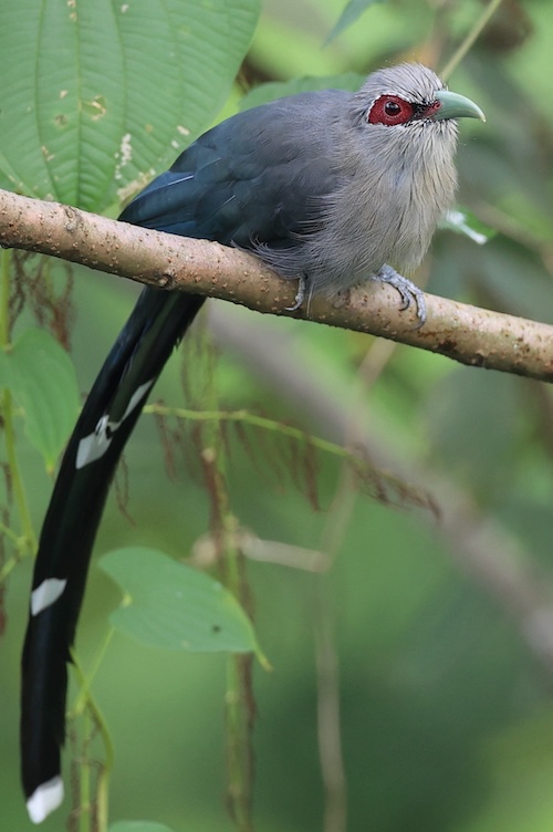
Green-billed Malkoha Phaenicophaeus tristis – ©Bird-Photo-Tours ASIA
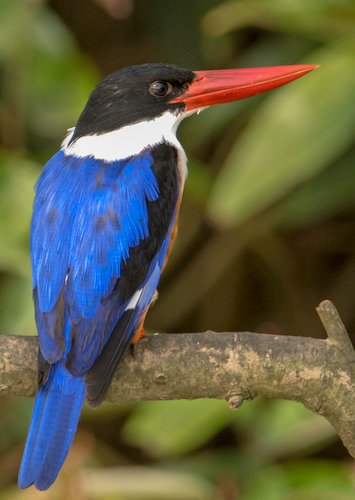
Manipur has a rich birdlife and has historically recorded many sought-after species such as Oriental Stork Ciconia boyciana, Greater Adjutant Leptoptilos dubius, White-winged Duck Cairina scutulata, Spot-billed Pelican Pelecanus philippensis, Baikal Teal Anas formosa, Baer’s Pochard Aythya baeri, Pallas’s Fish-Eagle Haliaeetus leucoryphus, Greater Spotted Eagle Aquila clanga, Lesser Kestrel Falco naumanni, Blyth’s Tragopan Tragopan blythii, Sarus Crane Grus antigone, Hooded Crane Grus monacha, Masked Finfoot Heliopais personata, Wood Snipe Gallinago nemoricola, Rufous-necked Hornbill Aceros nipalensis, Tawny-breasted Wren Babbler Spelaeornis longicaudatus, and Beautiful Nuthatch Sitta formosa. The status and present distribution record of many of these is uncertain as is the status of the state bird of Manipur, Mrs Humes Pheasant Syrmaticus humiae. However, it, along with Manipur Bush Quail Perdicula manipurensis and the endangered Green Peafowl Pavo muticus have a decreasing population.
Kailam Wildlife Sanctuary is known to hold Rufous-necked Hornbill Aceros nipalensis, a Vulnerable species, and Grey Sibia Heterophasia gracilis (a restricted Range species), but their status and distribution within the site is not known. There are records of Mrs Hume’s Pheasant Syrmaticus humiae from nearby areas, so it may occur in the park too. This site is best known for its hornbills: Brown Anorrhinus tickelli, Rufous-necked, Great Pied Buceros bicornis, Wreathed Aceros undulatus and Oriental Pied Anthracoceros albirostris. Given the extent of natural forests still remaining there, most of the restricted range species of the Eastern Himalayas EBA are likely to occur.
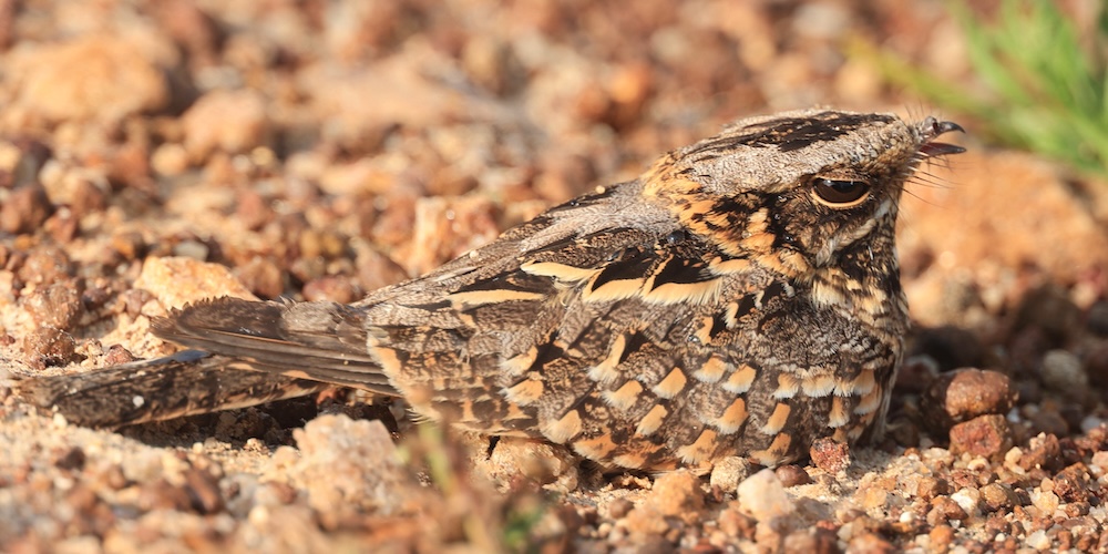
Indian Nightjar Phaenicophaeus tristis – ©Bird-Photo-Tours ASIA
The area lies in the general distribution range of the Leopard Panthera pardus, Golden Cat Catopuma temmincki, Serow Nemorhaedus sumatraensis, Hoolock Gibbon Hylobates hoolock, Stump-tailed Macaque Macaca arctoides and Asiatic Black Bear Ursus thibetanus.
This page is sponsored by Bird-Photo-Tours ASIA

-
Wikipedia
GNU Free Documentation License
https://en.wikipedia.org/wiki/Manipur
-
Number of bird species: 741
(As at July 2025)State Bird - Hume's Pheasant Syrmaticus humiae
-
Avibase
PDF ChecklistThis checklist includes all bird species found in Manipur , based on the best information available at this time. It is based on a wide variety of sources that I collated over many years. I am pleased to offer these checklists as a service to birdwatchers. If you find any error, please do not hesitate to report them. -
Bubo Birding
PDF ChecklistThis checklist includes all species that have been reported in Manipur in eBird, but updated to IOC taxonomy, together with the likelihood of seeing each species for each month of the year. -
E-Bird
PDF ChecklistThis checklist is generated with data from eBird (ebird.org), a global database of bird sightings from birders like you. If you enjoy this checklist, please consider contributing your sightings to eBird. It is 100% free to take part, and your observations will help support birders, researchers, and conservationists worldwide.

-
Birds of the Indian Subcontinent
| By Richard Grimmett, Carol Inskipp & Tim Inskipp | Helm | 2025 | Edition 2 | Paperback | 544 pages, 240+ plates with colour illustrations; colour distribution maps, b/w illustrations | ISBN: 9781472984777 Buy this book from NHBS.com
Birds of the Indian Subcontinent
Apple iOS | AndroidThe eGuide to Birds of the Indian Subcontinent is an interactive companion to Birds of the Indian Subcontinent – the definitive guide for birdwatchers visiting the region. It covers India, Pakistan, Nepal, Bhutan, Bangladesh, Sri Lanka and the Maldives. This application has specific features that will enhance your birding experience.
Indian Birds
Apple iOS | AndroidPioneers in bringing Indian Birding to the smart phone generation - Introducing Indian Birds, the time-honoured and cherished birding companion for India. Established in 2010, it proudly remains the sole mobile app available on App Store, offering bird enthusiasts the ability to explore bird namesOrganisationsReserves-
*Protected areas of Manipur
InformationSatellite ViewTwo national parks and at least one wildlife Sanctuary... -
IBA Loktak Lake (NP Keibul Lamjao)
InformationSatellite ViewA large freshwater lake supplied by seven streams entering from the north and west, and drained by the Manipur river to the south. A channel connects the lake with the Keibal Lamjao swamp. -
NP Keibul Lamjao
InformationSatellite ViewProminent bird species recorded in the park were both migratory and resident avifauna species. Some of them are East Himalayan Pied Kingfisher, Black Kite, Lesser Skylark, Northern Hill Myna, Burmese Pied Myna, North Indian Black Drongos, Lesser Eastern Jungle Crow, Yellow-headed Wagtail, Spotbill Duck, Blue-winged Teal, Ruddy Shellduck, Hooded Crane, Sarus Crane, Indian White-breasted Waterhen and Crimson-breasted Pied Woodpecker… -
NP Sirohi
InformationSatellite ViewA number of rivers originate from the cracks and slopes of this peak. The exotic Shirui lily flower (Lilium mackliniae) blooms on the hilltop in the month of May - June. The flower attracts hundreds of scientists and tourists every year. Rare birds like Blyth s Tragopan and Mrs. Hume s bar-backed pheasant inhabit the hill top. -
WS Kailam Wildlife Sanctuary
InformationSatellite ViewHere the bird life is extremely rich, like most of the tropical rainforest areas of Manipur. -
WS Yangoupokpi-Lokchao Wildlife Sanctuary
InformationSatellite ViewYangoupokpi-Lokchao Wildlife Sanctuary is an Indo-Burma wildlife sanctuary in Chandel district of Manipur. It is in the Indo-Myanmar border about 110 km from Imphal and has an area of 184.80 square kilometers.
Sightings, News & Forums-
eBird
SightingseBirding This Month
Guides & Tour Operators-
All India Birding Tours
Local Tour OperatorEast or Northeast India is a vast area comprising of Assam, Arunachal Pradesh, Meghalaya, Nagaland, Manipur, Sikkim, Tripura and Mizoram. The variations of altitude, diversity of habitat, and extreme precipitation are factors which are responsible for the diversity and abundance of resident birds in this region, To get to see the Black-necked Crane, White-belied Heron, Snowy-throated Babbler, Bugun Liochicla, Bengal Florican, Dark-rumped Swifts, White-winged Wood Duck, Beautiful Nuthatch, Rufous-necked, and Brown Hornbills, Black-necked crane, Tragopans, Blood Pheasants, Monal, Ibisbill, Purple cochoa, Blue-naped Pitta, Vivid Niltava, Long-billed plover, Wards Trogon, Grandala, Fire-tailed Myzornis and Black-headed Shrike-babbler, 13 Wren Babblers and the hub for Babblers to name just a few – take a trip to the North East. -
India Birdwatching
Local Tour Operator -
Zoothera Birding
Tour OperatorManipur - Today we will be looking for some very special birds that include Spot-breasted Scimitar-Babbler, Spot-breasted, Blue-winged, Striped & Moustached Laughingthrushes, Rusty-capped Fulvetta and a few other surprises too! However, Yellow-throated Laughingthrush is the standout star bird of this area and we will make every endeavour to find one.
Other Links-
Conservation
WebsiteManipur should be proud of her rich avi-Fauna. All the members of phasinidae are colorful but Mrs. Hume`s barred back Pheasant (Syrmaticus humiae) and Blyth's Tragopan found in Manipur are spectacular and stand out from the rest of the group. The Khaleej Pheasant found in Manipur is a rich mixture of steely black and white and is definitely quite elegant. The Burmese peafowls and jungle fowls are the other long feathered pheasants found in Manipur -
Important Bird Areas (IBAs)
WebpageThe Loktak Lake is the largest fresh water Lake of North-Eastern India which is also a Ramsar site and the Keibul Lamjao National Park is the only floating National Park in the world. Simply, Ramsar sites are Important Bird Areas where more than 20,000 migratory water birds congregate every year apart from presence of globally threatened species...
Fatbirder - linking birders worldwide...
Skip to content