
Free and Sovereign State of Chiapas
Chiapas is the southernmost state of Mexico and is bordered by the states of Tabasco to the north, Veracruz to the northwest, and Oaxaca to the west. To the east Chiapas borders Guatemala and to the south the Pacific Ocean. It has an area of over 74,000 km2 (c.28,600 square miles). It has a population more than 5.5 million people. Its capital and largest city is Tuxtla Gutiérrez whose metropolitan area has a population exceeding 850,000 inhabitants. Other important population centres in Chiapas include Ocosingo, Tapachula, San Cristóbal de las Casas, Comitán, and Arriaga.
Chiapas is geographically divided into six zones. These are the rainforest, the highlands, the central valley, the Sierra Madre de Chiapas, the Coastal Plains and the Soconusco:
Rainforest – The tropical rainforest of Chiapas, which includes the Selva Lacandona, is quickly being deforested. This is due to population pressures forcing highlanders into the rainforest. Migrants from Chiapas are being joined by Guatemalans fleeing the Civil War. These colonists constantly compete with one another for land, with the campesinos seizing or squatting on claimed land while landowners respond with the military or police. The economic activities of both groups contribute to the massive deforestation of the Lacandón. Rain falling on the forest drains into the Usumacinta river, which forms the border between Chiapas and the Petén department of Guatemala. The river flows into the sea in Tabasco.
Highlands – The Central Highlands have been the population centre of Chiapas since the Conquest. European epidemics were hindered by the tierra fría climate, allowing the indigenous peoples in the highlands to retain their large numbers. Indigenous peoples provided labour for Spanish conquistadors, who also heavily settled the highlands. Indigenous highlanders were conscripted into labour service on plantations, drafted into debt servitude, which was so widely practiced that Chiapas earned the illustrious title of ‘Mexico’s slave state’ in the late 19th century.
Sierra Madre de Chiapas – ©AlejandroLinaresGarcia CC BY-SA 3.0 via Wikimedia Commons
Central Valley – The Sierra Madre de Chiapas is cut through the middle by the Río Grande de Chiapas, known outside of Chiapas as Río Grijalva. The river flows from southwest to northeast. This area contains six of Chiapas’ seven hydroelectric plants. The construction of these dams flooded hundreds of thousands of hectares, making lakes out of former ejido lands. The capital of Tuxtla Gutiérrez is located in the Central Valley.
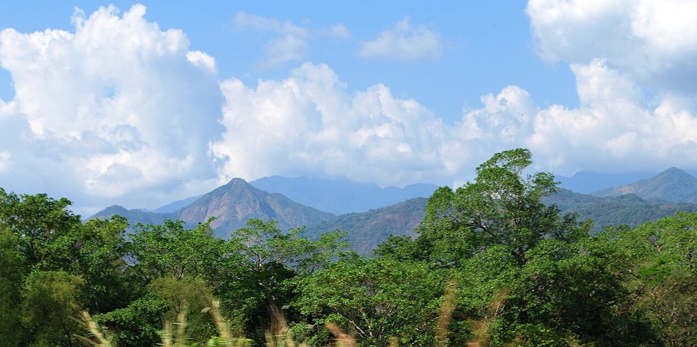
Sierra Madre de Chiapas – A continuation of the Sierra Madre del Sur, the Sierra Madre de Chiapas runs from northwest to southeast along the Pacific Ocean coast. It is extremely volcanic, resulting in high peaks, occasional eruptions and earthquakes, and rich soils. The mountains partially block rain clouds from the Pacific, a process known as Orographic lift, which creates a particularly rich coastal region called the Soconusco.
Coastal Plains – The Pacific Coast Plains is a strip of land parallel to the ocean. It is composed mostly of sediment from the mountains that border it on the northern side. It is uniformly flat, and stretches from the Bernal Mountain south to Tonalá. It has deep salty soils due to its proximity to the sea. It has mostly deciduous rainforest although most has been converted to pasture for cattle and fields for crops. It has numerous estuaries with mangroves and other aquatic vegetation. The Gulf Coast Plains (Llanura Costera del Golfo) stretch into Chiapas from the state of Tabasco, which gives it the alternate name of the Tabasqueña Plains. These plains are found only in the extreme north of the state. The terrain is flat and prone to flooding during the rainy season as it was built by sediments deposited by rivers and streams heading to the Gulf.
Soconusco – The Soconusco lies in the southernmost corner of Chiapas. It shares many ties with Guatemala, which claimed the territory until 1882. Since it was a part of the Aztec empire, Soconusco has been known for its agricultural products. Then it was cacao, now the main product is coffee, which is grown on large plantations. The tierra caliente climate of Soconusco allowed plantation agriculture to succeed, and in addition to coffee also grows sugar cane, rice, maize, and plantains.
Chiapas has about thirty percent of Mexico’s fresh water resources. The Sierra Madre divides them into those that flow to the Pacific and those that flow to the Gulf of Mexico. Most of the first are short rivers and streams; most longer ones flow to the Gulf. Most Pacific side rivers do not drain directly into this ocean but into lagoons and estuaries. The two largest rivers are the Grijalva and the Usumacinta, with both part of the same system. The state has thirty-six protected areas at the state and federal levels along with 67 areas protected by various municipalities. The Sumidero Canyon National Park extends over two of the regions of the state, the Central Depression and the Central Highlands.

Usumacinta River – ©Alfonsobouchot CC BY-SA 3.0 via Wikimedia Commons
In general, Chiapas has a humid, tropical climate. In the north, in the area bordering Tabasco, near Teapa, rainfall can average more than 120 inches per year. In the past, natural vegetation at this region was lowland, tall perennial rainforest, but this vegetation has been destroyed almost completely to give way to agriculture and ranching. Rainfall decreases moving towards the Pacific Ocean, but it is still abundant enough to allow the farming of bananas and many other tropical crops near Tapachula.
Birding Chiapas
Chiapas has one of the greatest diversities in wildlife in the Americas. There are more than 100 species of amphibians, 700 species of birds, fifty of mammals and just over 200 species of reptiles. In the hot lowlands, there are armadillos, monkeys, pelicans, wild boar, jaguars, crocodiles, iguanas and many others. In the temperate regions there are species such as bobcats, weasels, opossums, deer, ocelots and bats. The coastal areas have large quantities of fish, turtles, and crustaceans, with many species in danger of extinction or endangered as they are endemic only to this area. The total biodiversity of the state is estimated at over 50,000 species of plants and animals. The diversity of species is not limited to the hot lowlands. The higher altitudes also have mesophile forests, oak/pine forests in the Los Altos, Northern Mountains and Sierra Madre and the extensive estuaries and mangrove wetlands along the coast.
Volcan Tacana Biosphere Reserve – ©Eduardo Robles Pacheco CC BY 2.0 via Wikimedia Commons
The Lacandon Jungle, situated in north eastern Chiapas is centred on a series of canyon-like valleys called the Cañadas, between smaller mountain ridges oriented from northwest to southeast. The ecosystem covers an area extending from Chiapas into northern Guatemala and southern Yucatán Peninsula and into Belize. This area contains as much as 25% of Mexico’s total species diversity, most of which has not been researched. It has a predominantly hot and humid climate with most rain falling from Summer into Autumn. There is a short dry season from March to May. The predominant wild vegetation is perennial high rainforest. The Lacandon comprises a biosphere reserve (Montes Azules); four natural protected areas (Bonampak, Yaxchilan, Chan Kin, and Lacantum); and the communal reserve (La Cojolita), which functions as a biological corridor with the area of Petén in Guatemala. Flowing within the Rainforest is the Usumacinta River, considered to be one of the largest rivers in Mexico and seventh largest in the world based on volume of water.
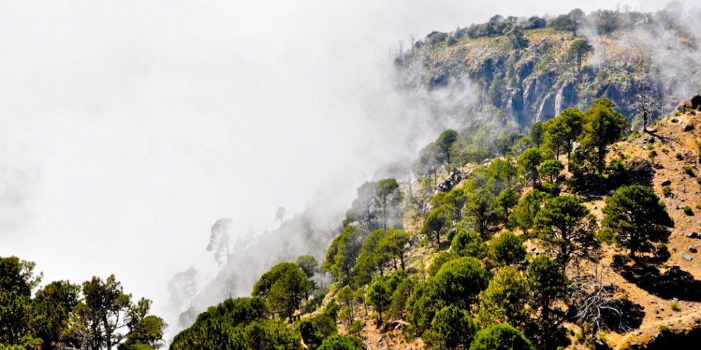
On the several parallel ‘sierras’ or mountain ranges running along the centre of Chiapas, climate can be quite temperate and foggy, allowing the development of cloud forests like those of the Reserva de la Biosfera el Triunfo, home to a handful of Resplendent Quetzals, Azure-rumped Tanagers and Horned Guans.
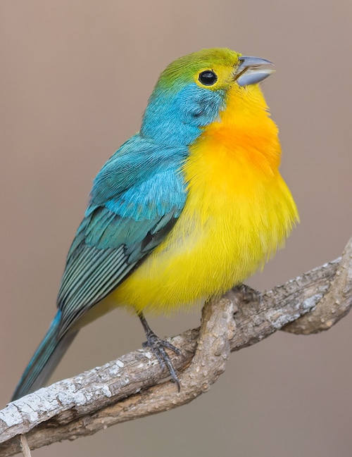
The very best birding sites include San Cristobal de las Casas, Comitan, the Sumidero Canyon, Isthmus of Tehuantepec, Tapachula and Volcan Tacana. The state offers a myriad of beautiful and sought-after species includes the amazing Giant Wren, the localised Nava’s Wren, dainty Pink-headed Warbler, Rufous-collared Thrush, Garnet-throated and Amethyst-throated Hummingbird, Rufous-browed Wren, Blue-and-white Mockingbird, Bearded Screech Owl, Slender Sheartail, Belted Flycatcher, Red-breasted Chat, Bar-winged Oriole, Lesser Ground Cuckoo, Lesser Roadrunner, Cabanis’s Wren, Mayan Antthrush, Orange-breasted and Rose-bellied Bunting, West Mexican Chachalaca, Citreoline Trogon, Yellow-eyed Junco, Unspotted Saw-whet Owl and Long-tailed Sabrewing. Not to mention the incredible Horned Guan, Emerald-chinned, Wine-throated and Azure-crowned Hummingbird and at night the haunting Fulvous Owl! At least 25 of Mexico’s endemics occur in the state.
-
Wikipedia
GNU Free Documentation License
https://en.wikipedia.org/wiki/Chiapas
-
Number of bird species: 762
(As at November 2024)
-
Avibase
PDF ChecklistThis checklist includes all bird species found in Chiapas , based on the best information available at this time. It is based on a wide variety of sources that I collated over many years. I am pleased to offer these checklists as a service to birdwatchers. If you find any error, please do not hesitate to report them. -
eBird
PDF ChecklistThis checklist is generated with data from eBird (ebird.org), a global database of bird sightings from birders like you. If you enjoy this checklist, please consider contributing your sightings to eBird. It is 100% free to take part, and your observations will help support birders, researchers, and conservationists worldwide.
-
Chiapas Birding & Photo Festival
Festival Websiteonferences, Bird Watching, Hiking in Natural Protected Areas.
-
Chiapas Birding Club - Observadores de Aves
Facebook PageSomos observadores y fotógrafos de aves del Estado de Chiapas que gustan de observar, estudiar y divulgar el conocimiento sobre las aves y su importancia en el entorno natural y cultural.
-
*Protected areas of Chiapas
InformationSatellite ViewInteractive list of Biosphere reserves etc. -
BR El Triunfo
WebpageSatellite ViewEl Triunfo Biosphere Reserve (REBITRI) is considered one of the Protected Natural Areas with more species of terrestrial vertebrates. These species represent the 24% at a national level and 47% statewide (Altamirano González-Ortega, 2007)… -
BR La Sepultura Biosphere Reserve
InformationSatellite ViewResident birds include psittaciformes such as the white-fronted (Amazona albifrons) and yellow-naped parrots (Amazona auropalliata), several species of hummingbird, quetzals, toucans, and trogons. Carnivorous and predatory bird species include a range of New World vultures, owls, and raptors, such as the gray hawk (Buteo plagiatus), Swainson's hawk (Buteo swainsoni), solitary eagle (Buteogallus solitarius), king vulture (Sarcoramphus papa), turkey vulture, black vulture, and the peregrine falcon (Falco peregrinus). 90 species of migratory birds visit the reserve -
BR Lacan-Tun Biosphere Reserve
InformationSatellite ViewLacan-Tun Biosphere Reserve borders Montes Azules Biosphere Reserve on the southwest, and is bounded by the Lacantun River on the southeast. -
BR Montes Azules
WebpageSatellite ViewLocated between the Guatemalan border and the Montes Azules Biosphere Reserve in Chiapas, Mexico, lies a tract of unprotected rainforest in danger of disappearing. This region bordering the Biosphere Reserve now has a chance at survival thanks to a series of conservation efforts established by Montes Azules… -
BR Montes Azules Reserva Ecológica
WebpageSatellite ViewThe Montes Azules Biosphere Reserve is a protected natural area located in the extreme east of the state of Chiapas , in Mexico . It was decreed as a reservation by the government of Mexico in 1978 . It is located in the central zone of the Lacandona Forest
-
eBird
SightingseBirding This Month
-
BirdQuest
Tour OperatorThe Ultimate specialities itinerary, including Oaxaca, Chiapas, Veracruz and the Yucatan -
Eagle-Eye Tours
Tour OperatorSuperb birding in a wide variety of habitats, including the spectacular Sumidero Canyon and the pre-Columbian pyramids at Palenque. -
Field Guides
Tour OperatorFor this tour, we head all the way south to Chiapas. With its colossal mangroves, coastal savannahs, tropical dry forests, and orchid-filled cloud forests, Chiapas is home to a dazzling array of birds, many of which are found nowhere else. -
Kolibri Expeditions
Tour OperatorTriunfo hike with Horned Guan, Resplendent Quetzal and Tody Motmot is a birding classic that everyone needs to do once. One hikes from the Atlantic slope to the Pacific Slope in beautiful cloud forest. -
Legacy Tours
Tour OperatorEl Triunfo Biosphere Reserve The Sierra Madre del sur de Chiapas -
Mexico Birding Tours
Tour OperatorChiapas is considered in Mexico as the green state, it has more protected areas than any other state in Mexico, Chiapas is also synonym of Mayas and Rainforest, we have a 15 day trip that covers outstanding habitats -
Pitta Nature Tours
Tour OperatorIn southern Mexico, the state of Chiapas and the Isthmus of Tehuantepec is the meeting place of avifauna between the north and south where more than 40 endemic and near endemic species occur, and the state boasts a list of nearly 700 birds. -
Rockjumper
Tour OperatorChiapas is the southernmost state of Mexico, located on the border of Guatemala. Our tour of Chiapas takes in the very best of the areas birding sites such as San Cristobal de las Casas, Comitan, the Sumidero Canyon, Isthmus of Tehuantepec, Tapachula and the slopes Volcan Tacana. -
Royal Flycatcher Birding Tours
Local Tour OperatorBirds, Culture and Conservation -
Travelian Tour
Tour OperatorTake an extraordinary Travelian Tour for nature and birding and visiting remarkable Mayan ruins in the highland pine forests and untouched jungles of Chiapas with us and our expert local guides! -
WINGS
Tour OperatorWe’ll start in Tuxtla Gutiérrez, a modern city and the state capital of Chiapas, which lies within driving distance of habitats ranging from arid scrub to rain forest and humid pine-oak highlands. We’ll head next to Arriaga, on the Pacific side of the isthmus, and then move west and north to end in Oaxaca City, a time-honored favorite of birders and travelers.
-
2019 [03 March] - Nick Athanas - Oaxaca & Chiapas
PDF ReportMarch in much of the Northern Hemisphere was rather dreary, but in southern Mexico we enjoyed day after day of warm, sunny days and cool, pleasant evenings – it was a wonderful and bird-filled reprieve from winter for the whole group including me. -
2023 [02 February] - Hector Gomez de Silva
ReportThe number of species and of Mexican endemics and specialties was spectacular. A total of 337 species seen and 29 additional ones heard; many of these are endemic or nearly endemic to Mexico, including the highly sought after Bumblebee Hummingbird, Garnet-throated Hummingbird, Rosita’s (Rose-bellied) Bunting, Nava’s Wren and Giant Wren -
2023 [03 March] - Micah Riegner
Report...After a picnic breakfast among chattering Black-headed Saltators and Black-faced Grosbeaks, we continued birding the main road. A Green Shrike-Vireo and Golden-hooded Tanagers got our attention shortly before we heard the loud, rich, whimsical song of Nava’s Wren, our primary target for the morning. The bird hopped down a limestone slope and sang right in front of us for several minutes—we couldn’t have asked for more! -
2024 [02 February] - Hector Gomez de Silva
ReportA total of 409 species seen by the participants plus 3 leader-only and 22 additional ones heard; many of these are endemic or nearly endemic to Mexico, including the highly sought after Bumblebee Hummingbird, Garnet-throated Hummingbird, Rosita’s (Rose-bellied) Bunting, Nava’s Wren and Giant Wren.
-
Casa Felipe Flores
AccommodationThis historic landmark bed and breakfast located in Mexico`s most charming colonial city -
SOL y LUNA Guest Inn
AccommodationEnjoy the warm hospitality of Mexico in the colonial splendor of SOL y LUNA Guest Inn & Breakfast while visiting the mountains, gardens and indigenous villages that surround San Cristobal de las Casas, Chiapas