
Free and Sovereign State of Nayarit
Nayarit is one of the 31 states that, along with Mexico City, comprise the Federal Entities of Mexico. It is divided in 20 municipalities and its capital city is Tepic. It is located on the central west coast, bordering the Pacific Ocean. Nayarit is surrounded by the states of Sinaloa to the northwest, Durango to the north, Zacatecas to the northeast and Jalisco to the south with the Pacific Ocean bordering it to the west. The state covers almost 28,000 km2 (over 10,000 square miles), making it one of the smaller states of Mexico. Its terrain is broken up by the western ends of the Sierra Madre Occidental mountains. Its highest mountains are: San Juan, Sanguangüey, El Ceboruco, Cumbre de Pajaritos and Picachos and it has two volcanoes, Ceboruco and Sangangüey. In the northeast are broad, tropical plains watered by the Río Grande de Santiago, a continuation of the Lerma River. Its other main rivers are the San Pedro, Acaponeta, Ameca and Las Cañas. The last two also form natural boundaries with the states of Jalisco and Sinaloa, respectively. Nayarit also has several lagoons such as the Santa María del Oro, San Pedro Lagunillas and Agua Brava.
Nayarit’s natural vegetation varies with altitude; coastal lowlands and river valleys were, historically, covered with tropical dry forest, containing many native deciduous trees that lost their leaves during the dry seasons. The Sinaloan dry forests now cover the northern coastal lowlands, and extend up the valleys of the San Pedro Mezquital River and the Río Grande de Santiago and its tributaries. The Jalisco dry forests ecoregion covers coastal Nayarit south of San Blas and the Islas Marías. The Marismas Nacionales-San Blas mangroves, a network of coastal Pacific lagoons and tidal mangrove forests, extend along the state’s northern coast and into adjacent Sinaloa state. The mangroves are home to abundant wildlife, including migratory and resident waterbirds. The mountains are home to pine-oak forests, which vary in density with elevation. Oak forests and woodlands tend to grow at lower elevations, interspersed with smaller areas of humid cloud forest in areas of higher rainfall. The highest elevations contain forests of conifers, pines and oak.
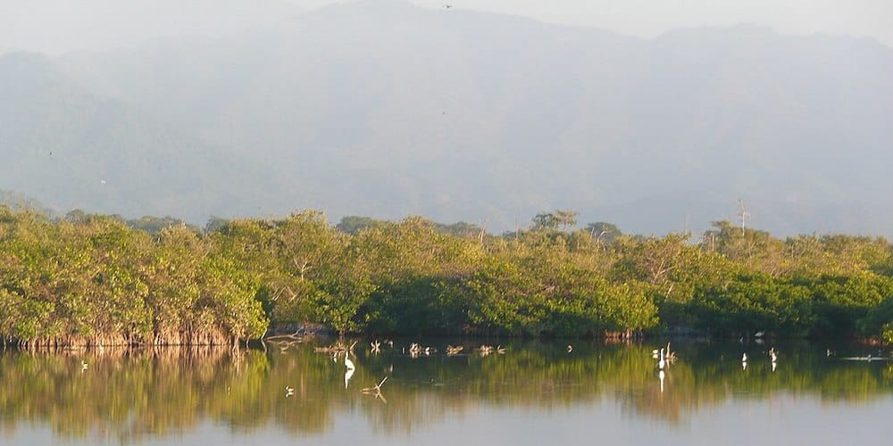
Marismas Nacionales-San Blas Mangroves – ©Oescalona CC BY-SA 3.0 via Wikimedia Commons
Nayarit is predominantly an agricultural state, and produces a large variety of crops such as beans, sorghum, sugar cane, maize, tobacco, rice, chiles, peanuts, melons, tomatoes, coffee, mangoes, bananas, and avocados. In addition to these crops, livestock and fishing are also central to the local economy. Approximately six percent of the land in Nayarit is pasture land, with the most common livestock being cattle, horses, pigs, goats, and sheep. Nayarit has 289 kilometres of coastline, which provides an abundance of fish and shellfish, including bass, snapper, sharks, and oysters. There are over 75 cooperatives related to the fishing industry alone in Nayarit. Much of the food produced in Nayarit is exported to the larger urban areas surrounding Mexico City and Guadalajara, and much of the agricultural labor is performed by migrant laborers. Although mining exists in Nayarit, it is mostly of non-metallic substances such as limestone or kaolin.
Birding Nayarit
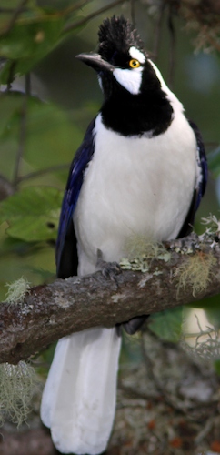
Nayarit also contains hundreds of miles of rainforest in the Sierra. Its wildlife includes hundreds of bird species, both resident and breeding/migratory populations, including parrots, like the lilac-crowned Amazon Amazona finschi and numerous hummingbirds, such as the Mexican Woodnymph Thalurania ridgwayi. There are also 119 species of mammals, including collared peccary, brocket deer, several types of armadillo, coyote, wild felines such as puma, jaguarundi, bobcat and ocelot. Historically, the Mexican wolf, Mexican grizzly bear and jaguar would have been present in the region as well, although the bears are now extinct; the Mexican wolf and jaguar survive in a few fragmented locations, due to decades of hunting and human encroachment on their habitats. Most of the rain forest has been exploited, especially around the region of Santa María del Oro. The conservation and protection of the rain forest and wildlife of Nayarit is an issue of crucial importance. The Islas Marías were designated as the Islas Marías Biosphere Reserve by UNESCO.
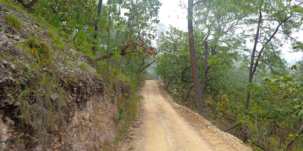
Sierra Madre Occidental – ©Santoclost CC BY-SA 4.0 via Wikimedia Commons
A locally based birder kindly submitted the following notes on the birding opportunities provided by this under-watched state:
The City of San Blas and area was once a quiet fishing village, but it has changed a lot in recent years. Nevertheless, it’s still one of the best birding areas in Mexico. It has at least seven different eco-systems.
Great birding is to be had on Peso island, (called that because they used to charge one (1) peso for a boat trip to the island), but of course the price has gone up since then.
Next is the Fort & Cemetery – Sewage pond road.
Then comes a trip up the Rio San Cristobol River – take this in the early morning and set things up in advance for the best birding.
Take the trip to La Tovara in the evening looking for the Northern Potoo, owls & much more. You can take the trip in the La Tovara lagoon in the early morning, but again you need to put everything in place in advance for this trip too.
El Pozo Estuary can be excellent – again make reservations beforehand.
Other nearby birding hotspots to see are the Shrimp Ponds, Guadalupe Victoria Road, Roadside lagoon, Chacalilla, Singayta, Mecatan West Entrance, El Palillo, Cocodrilario Road, and La Bajada. Mirador del Aguila is the place to find Military Macaws, Rancho La Noria is also great is.
As if that is not enough, you can also go whale watching locally!
-
La Laguna de Santa Maria del Oro
WikiSatellite ViewLa Laguna de Santa Maria del Oro, is a volcanic crater lake in western Mexico, near Tepic in the foothills of the sierra Madre mountains, the picturesque lake of about 2km diameter is located at 2300ft altitude, and is surrounded by mountains rising to about 3500ft nearby, and 6000ft further away (the first range of the sierra Madre). There are over 260 different species seen with in 10 miles of the lake. There are a variety of habitats, lake streams agriculture fields thorn forests, tropical deciduous forest, pine-oak forest scrub. It offers excellent winter birding in a moderately warm and dry climate in the transition zone between the coastal lowlands and the interior highlands (San Blas is only a two hours away)
-
Number of bird species: 606
(As at December 2024)State Bird: Eared Quetzal Euptilotis neoxenus
-
Avibase
PDF ChecklistThis checklist includes all bird species found in Nayarit , based on the best information available at this time. It is based on a wide variety of sources that I collated over many years. I am pleased to offer these checklists as a service to birdwatchers. If you find any error, please do not hesitate to report them. -
eBird
PDF ChecklistThis checklist is generated with data from eBird (ebird.org), a global database of bird sightings from birders like you. If you enjoy this checklist, please consider contributing your sightings to eBird. It is 100% free to take part, and your observations will help support birders, researchers, and conservationists worldwide.

-
Birds of Mexico and Central America
| By Ber van Perlo | PUP | 2006 | Paperback | 336 pages, 98 plates with colour illustrations; b/w illustrations, b/w distribution maps, colour maps Publisher: Princeton University Press | ISBN: 9780691120706 Buy this book from NHBS.com
-
Festival Internacional de Aves Migratorias de San Blas Nayarit
Facebook PageProyecto con sentido comunitario, somos una herramienta que trabaja para potencializar el desarrollo socioeconómico de la región de San Blas, Nayarit -
International Migratory Bird Festival of San Blas
WebpageThe International Festival of Migratory Birds of San Blas, Nayarit contributes and strengthens the preservation of the habitat of migratory birds of the region and the improvement of the community’s quality of life, by being involved it in the conservation of its environment.
-
San Pancho Bird Observatory
Observatory WebsiteSatellite ViewObservatorio de Aves de San Pancho (SPBO—San Pancho Bird Observatory) is a non-profit, non-advocacy organization based in San Pancho on the coast of southern Nayarit, Mexico. SPBO is dedicated to bird and habitat conservation in the region and uses an approach to conservation based on the integration of bird population monitoring, education, and ecotourism programs. SPBO partners with the San Pancho Birding Club in many local community and school education programs.
-
Club de Observadores de Aves de Nayarit
Facebook PageWe are a group dedicated to promoting the hobby of bird watching, and the conservation of birds, their habitat and the environment.
-
NP Isla Marietas
InformationSatellite ViewThe Marieta Islands (Spanish: Islas Marietas) are a group of small uninhabited islands a few miles off the coast of Nayarit, Mexico. They are very popular tourist destinations because of the abundant marine life populations due to the islands being protected from fishing and hunting by the Mexican government. -
NR La Tovara Nature Reserve
InformationSatellite ViewThe Marismas Nacionales–San Blas mangroves occupy an area of 2,000 square kilometers (770 sq mi) in coastal Nayarit and Sinaloa states. -
Protected areas of Nayarit
InformationSatellite ViewParks & Reserves
-
Vidanta Nuevo Vallarta Resort
SightingseBirding This Month
-
Mexican Birding
Local Tour OperatorLocal tours -
Nature Vallarta
Local Tour OperatorBirding Tours in Puerto Vallarta and Riviera Nayarit -
Riviera Nayarit
Local Tour OperatorBird Watching and Birding Tours in Riviera Nayarit Mexico - Riviera Nayarit, located on the Pacific west coast just north of Puerto Vallarta, is one of 31 Mexican states and is regarded as home to some of the world’s best bird watching locations for vacationing birdwatchers, especially during the months of October through to March. -
Rockjumper
Tour OperatorMexico - Northwest: Sinaloa, Nayarit & Jalisco -
Sayulita Birdwatching Tours
Local Tour OperatorCurrently I personally make plumage identification, nesting in addition to organizing excursions in the state of Nayarit and part of Jalisco for bird watching, where I share my passion for Nature and the Birds!
-
2022 [12 December] - Pritam Baruah
PDF ReportThe endemic rich region of Western Mexico has been on my to do list for many years. I had finally booked a trip for Feb 2022 but because of a personal situation, I had to cancel it days before the trip. I hadn’t thought about planning a make-up until a last-minute travel opportunity suddenly opened in an inflexible window of time... -
2023 [03 March] - Hans Matheve & Joachim Teunen
Report...We opted not to do as no ‘hard’ targets were there for us. We would include Paso Ancho on the way up from El Tuito towards San Blas... -
2024 [03 March] - Henk Hendriks
PDF Report...As soon as we arrived we observed a couple of Black-vented Orioles in the palm trees at the start of the track. Antonio noticed the call of Purplish-backed Jay nearby and it did not take long before we found a single Purplish-backed Jay. It turned out that this was only observation of this species during our trip. Because of the obvious yellow bill it was a juvenile bird... -
2024 [04 April] - Ornis Birding Expeditions
PDF ReportA last full day at San Blas had four key remaining targets at the top of our agenda. The marsh in Tepic produced a showy Spotted Rail in the early hours, before we headed to the forested slopes of San Juan again. This time we found Greycollared Becard and “Dickey’s” Audubon’s Oriole with relative ease, before we returned to the marsh and finally found an Aztec Rail in the late afternoon. Four for four! Spotlighting for Northern Potoo was successful, and we also found two nocturnal Boat-billed Heron feeding in a flooded area, a great conclusion to our time on the central coast.
-
Hotel Garza Canela
AccommodationDiscover San Blas -
Koala Bungalows
AccommodationMany species may be found around Koala and within a short distance of the lake. The beautiful magpie jays are everywhere and painted buntings are often spotted. The first birding fesival for the "lagunas encantadas" was held from 2nd to 9th of March this year (2012)… -
Playa Las Tortugas [Turtle Beach]
AccommodationCome stay at the villas of Playa Las Tortugas, adjacent to a spectacular beach, and protected estuary which is home to hundreds of bird species and other animals. -
Villa Bella B&B
AccommodationLa Cruz de Huanacaxtle is a small fisherman village ten minutes north of Puerto Vallarta
-
Birding San Blas
InformationSan Blas is one of the main places for bird watching on the west coast of Mexico due to the diversity of habitats that include: Rainforests, sea and beaches, mangroves and marshes, estuaries and lagoons, mountain forests of pine and oak, and islands, all of which host easily accessible birding sites. Within a 50 kilometer radius you can go from one habitat to another, via boat trips through mangroves or by open sea, or just hiking along the typical villages of the coast and mountains.